Hi Ben and Rick,
I am trying to do flattens in FSX using fsx_kml_110 and/or SbuilderX neither of which can I get to co operate.
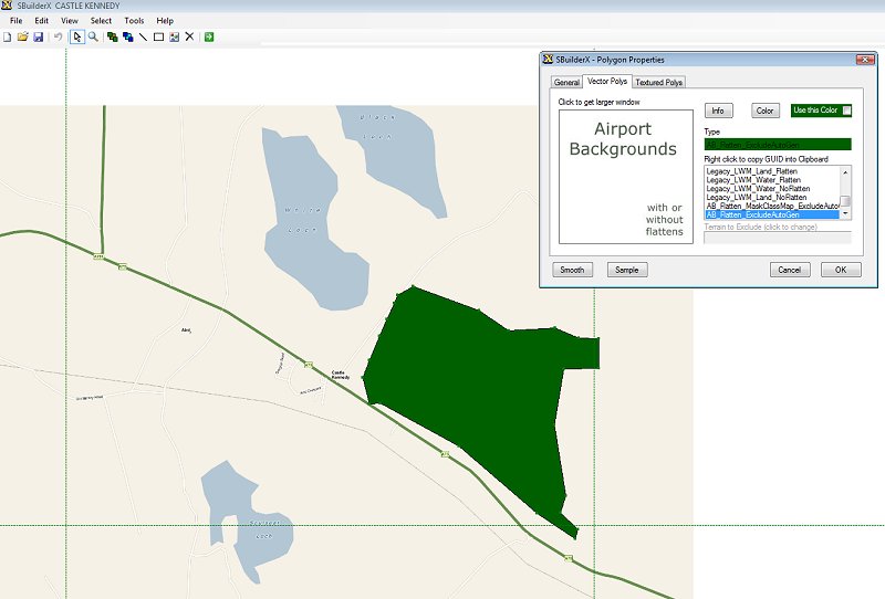
Ben, this is what I got off Google Earth and how fsx_kml handled it. Can you please post a good flatten kml so I can see how it is made up zero altitude was selected in Google Earth but I see no mention of altitude.
Rick will have another crack at SBuilderX again later, Thanks to both
KML off Google Earth, the KML was proccesed by fsx_kml_110 with no complaints is there something missing.
<?xml version="1.0" encoding="UTF-8"?>
<kml xmlns="
http://earth.google.com/kml/2.1">
<Document>
<name>ark flat.kml</name>
<Style id="sh_ylw-pushpin_copy:0_copy6">
<IconStyle>
<scale>1.3</scale>
<Icon>
<href>
http://maps.google.com/mapfiles/kml/pus ... .png</href>
</Icon>
<hotSpot x="20" y="2" xunits="pixels" yunits="pixels"/>
</IconStyle>
</Style>
<Style id="sn_ylw-pushpin_copy:0_copy1">
<IconStyle>
<scale>1.1</scale>
<Icon>
<href>
http://maps.google.com/mapfiles/kml/pus ... .png</href>
</Icon>
<hotSpot x="20" y="2" xunits="pixels" yunits="pixels"/>
</IconStyle>
</Style>
<StyleMap id="msn_ylw-pushpin_copy:0_copy7">
<Pair>
<key>normal</key>
<styleUrl>#sn_ylw-pushpin_copy:0_copy1</styleUrl>
</Pair>
<Pair>
<key>highlight</key>
<styleUrl>#sh_ylw-pushpin_copy:0_copy6</styleUrl>
</Pair>
</StyleMap>
<Placemark>
<name>ark flat2</name>
<description>Airport_Backgrounds_Flatten</description>
<styleUrl>#msn_ylw-pushpin_copy:0_copy7</styleUrl>
<Polygon>
<tessellate>1</tessellate>
<outerBoundaryIs>
<LinearRing>
<coordinates>
120.7619990762013,14.48744396448807,0 120.7591037974905,14.48495192319482,0 120.7562085297311,14.48308330092284,0 120.7533134817842,14.48059140000234,0 120.7510614031736,14.47934614152734,0 120.7484870575256,14.47716690920435,0 120.7465559608257,14.47405297916093,0 120.744946760058,14.47156183774735,0 120.7436590662429,14.46813614535907,0 120.742693107999,14.46471032456929,0 120.7423706066276,14.46128428858401,0 120.7426921708322,14.4584806379203,0 120.7436574127325,14.45505368135232,0 120.745587843427,14.45256087543459,0 120.7481616303497,14.45037934695104,0 120.7517003997707,14.44882041912702,0 120.7549169141496,14.44726183910824,0 120.758133556493,14.44726053426036,0 120.7619933026418,14.4472589591622,0 120.7639224600619,14.44725859558096,0 120.7690668455811,14.44663463218072,0 120.772925532245,14.4466336540733,0 120.776463480105,14.44787826263378,0 120.7803232076578,14.44943422501159,0 120.7845045544822,14.45036689083304,0 120.7861133778385,14.45254666571569,0 120.7864360884353,14.45628485029283,0 120.786437097047,14.45940009804976,0 120.7864383635543,14.46282667940496,0 120.7874047016914,14.4662527643681,0 120.7883709603298,14.46936738574939,0 120.7890160376621,14.4737283690348,0 120.7870863835538,14.4752872428995,0 120.7867657464952,14.47840310456022,0 120.7848367098681,14.48245489870857,0 120.7819416467366,14.48307887388075,0 120.7787253940004,14.48494890843103,0 120.7761525471235,14.48744210591251,0 120.7735792717999,14.48775389167517,0 120.7697193837234,14.48775408299221,0 120.7677892900533,14.48775446483302,0 120.7619990762013,14.48744396448807,0 </coordinates>
</LinearRing>
</outerBoundaryIs>
</Polygon>
</Placemark>
</Document>
</kml>
_____________________________________________________________________________________________
XML compiled by fsx_kml_110
<?xml version="1.0"?>
<metadata xml:lang="en">
<FlightSim>
<Geometry clipLevel="11"></Geometry>
<AttributeSet>
<AttributeBlock name="AirportBounds" guid="{359C73E8-06BE-4FB2-ABCB-EC942F7761D0}">
<Field name="Uuid" type="GUID" />
</AttributeBlock>
<AttributeBlock name="Texture" guid="{1B6A15BB-05FB-4401-A8D1-BB520E84904C}">
<Field name="Guid" type="GUID" />
</AttributeBlock>
</AttributeSet>
</FlightSim>
</metadata>
_____________________________________________________________________________________________
Dissasembled bgl ??? nothing in the bgl
<?xml version="1.0"?>
<!-- cvxARK FLAT.BGL disassembled by BglAnalyzeX Tue Dec 09 08:20:40 2008 -->
<FSData version="9.0"
xmlns:xsi='
http://www.w3.org/2001/XMLSchema-instance'
xsi:noNamespaceSchemaLocation="bglcomp.xsd">
</FSData>